The Crew's Story
A lengthy article in the New York Times tells the story of the San Francisco grounding from the crew's point of view (registration probably required soon). While some of us have our own opinions of Christopher Drew, in this case I think he did a good job of bringing to the forefront the bravery and professionalism of the crew in their response to the casualty, and balancing the navigational mistakes made on board with other, more systemic, Force-wide issues. Some excerpts:
"To avoid detection, submarines travel silent and largely blind, relying heavily on charts, and their interpreters, to navigate the undersea landscape. The meeting of this submarine and that mountain beneath the Pacific was in many ways a stroke of hauntingly rare bad luck: everyone relied on the one chart, from a panoply of them, that lacked even a hint of the looming danger. But the submarine's fate was also the result of a confluence of simple shipboard errors.
"The Navy has placed the blame on the captain and the crew, and Commander Mooney says, "I accept full responsibility." He acknowledges several critical mistakes, including going too fast, taking insufficient depth soundings and failing to cross-check the route with other charts...
"The goal of the routings was to ensure that no other Navy ship would cross the submarine's path, and they laid out a wide track to follow. But some officers had come to view these navigational guides as suggesting a measure of safety. And as the San Francisco left here on Friday, Jan. 7, the team plotting the precise route within that track focused on a single set of charts that, Navy officials agree, usually gave the most detailed view of the seabed.
"Since submarines generally do not use active sonar, with its telltale pings, a good picture can be critical in avoiding mountain ranges rising from the seabed. Relying on charts, though, has always been somewhat hit or miss. Only 10 percent of the oceans have been charted by Navy survey ships. Many charts only include obstacles spotted by warships, commercial vessels or even 18th-century explorers like Captain Cook..."
Sure, there are some problems with the article (seeming to think "Corpsman" is rank like "Petty Officer" or "Commander", a reference to a "smoking room" when he obviously meant "smoking area"), but they really don't detract from the overall excellence of the piece. I highly recommend reading the whole article (five pages).
Staying at PD...
Update 2119 17 May: Although not listed on their website, 60 Minutes Wednesday is apparently still going to be broadcasting their piece on the SFO grounding tomorrow night.
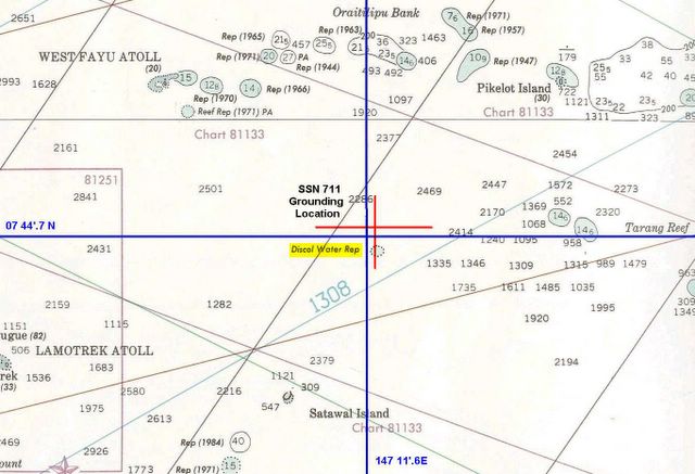
Update 2237 17 May: Still catching up from my trip... from almost a week ago, Lubber's Line has the location of the San Francisco grounding plotted on a chart he ordered that shows the location of the "discolored water" along with SFO's position at the time of the grounding. I was interested to see the relative paucity of soundings in that specific area of the grounding, compared with the area just to the east (which includes two shallow spots).
Update 0728 18 May: More extended excerpts that should last a couple of weeks, and don't require registration.
posted by Bubblehead at 8:55 PM
![]()


0 Comments:
Post a Comment
<< Home